
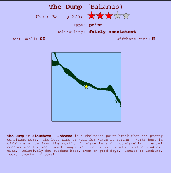
The Dump Surf Guide
The Dump in Eleuthera is a sheltered point break that has pretty consitent surf. The favoured time of year for waves is autumn. The best wind direction is from the north. Windswells and groundswells in equal measure and the ideal swell direction is from the southeast. Best around mid tide. Relatively few surfers here, even on good days. Watch out for urchins, rocks, sharks and coral.
The Dump Spot Info
| Type: | Rating: | Reliability: | Todays Sea Temp*: |
|---|---|---|---|
| fairly consistent | 30.3°C*ocean temperature recorded from satellite |
Surfing The Dump:
The best conditions reported for surf at The Dump occur when a Southeast swell combines with an offshore wind direction from the North.
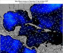
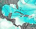
Voorspelde Golfenergie (Kracht): 12 uur

The Dump Surf:
Monday, 13 July 2026, 10:14 Local time| Monday 13 | ||||
| 11AM | 2PM | 5PM | 8PM | |
| Wave (m) | ||||
| Periode (s) | 8 | 8 | 8 | 8 |
| Wind (km/h) | ||||
| Wind | cross- on |
cross- on |
cross | cross |
- /breaks/The-Dump_2/forecasts/latest
The Dump Surf Guide
The Dump in Eleuthera is a sheltered point break that has pretty consitent surf. The favoured time of year for waves is autumn. The best wind direction is from the north. Windswells and groundswells in equal measure and the ideal swell direction is from the southeast. Best around mid tide. Relatively few surfers here, even on good days. Watch out for urchins, rocks, sharks and coral.
The Dump Spot Info
Type: Rating: Reliability: Todays Sea Temp*:  Point
Point 3
3fairly consistent 30.3°C*ocean temperature recorded from satelliteSurfing The Dump:
The best conditions reported for surf at The Dump occur when a Southeast swell combines with an offshore wind direction from the North.
Voorspelde Golfenergie (Kracht): 12 uur
Gebruik de tabbladen hierboven om de zeewatertemperatuur bij The Dump te bekijken, foto's van The Dump, The Dump gedetailleerde golfvoorspellingen, wind- en weersvoorspellingen, The Dump webcams, actuele wind in Eleuthera live weerstations en The Dump getijdenvoorspellingen. De link van Bahamas golfkaarten opent een grote afbeelding van Bahamas en de omliggende zeeën. Deze golfkaarten kunnen worden dynamisch gemaakt worden met de verschillende golfcomponenten, golfenergie, golfperiode, golfhoogte, samen met de wind en weersvoorspellingen, het actuele weer en de zeetoestand volgens golfboeien uit Bahamas, langskomende schepen en weerstations op de kust. Elk voorspelling pagina's voor dit surfstrand zijn voorzien van een wereldwijde en regionale golfzoeker om de beste surfsomstandigheden in het gebied rond The Dump te vinden.
The Dump Surf:
Monday, 13 July 2026, 10:14 Local timeMonday 13 11AM 2PM 5PM 8PM Wave (m) Periode (s) 8 8 8 8 Wind (km/h) Wind cross-
oncross-
oncross cross - /breaks/The-Dump_2/forecasts/latest
- /breaks/The-Dump_2/forecasts/latest/six_day
The Dump Surf Guide
The Dump in Eleuthera is a sheltered point break that has pretty consitent surf. The favoured time of year for waves is autumn. The best wind direction is from the north. Windswells and groundswells in equal measure and the ideal swell direction is from the southeast. Best around mid tide. Relatively few surfers here, even on good days. Watch out for urchins, rocks, sharks and coral.
The Dump Spot Info
Type: Rating: Reliability: Todays Sea Temp*: Point3fairly consistent 30.3°C*ocean temperature recorded from satelliteSurfing The Dump:
The best conditions reported for surf at The Dump occur when a Southeast swell combines with an offshore wind direction from the North.
Voorspelde Golfenergie (Kracht): 12 uur
Gebruik de tabbladen hierboven om de zeewatertemperatuur bij The Dump te bekijken, foto's van The Dump, The Dump gedetailleerde golfvoorspellingen, wind- en weersvoorspellingen, The Dump webcams, actuele wind in Eleuthera live weerstations en The Dump getijdenvoorspellingen. De link van Bahamas golfkaarten opent een grote afbeelding van Bahamas en de omliggende zeeën. Deze golfkaarten kunnen worden dynamisch gemaakt worden met de verschillende golfcomponenten, golfenergie, golfperiode, golfhoogte, samen met de wind en weersvoorspellingen, het actuele weer en de zeetoestand volgens golfboeien uit Bahamas, langskomende schepen en weerstations op de kust. Elk voorspelling pagina's voor dit surfstrand zijn voorzien van een wereldwijde en regionale golfzoeker om de beste surfsomstandigheden in het gebied rond The Dump te vinden.
The Dump Surf:
Monday, 13 July 2026, 10:14 Local timeMonday 13 11AM 2PM 5PM 8PM Wave (m) Periode (s) 8 8 8 8 Wind (km/h) Wind cross-
oncross-
oncross cross - /breaks/The-Dump_2/forecasts/latest
The Dump Surf Guide
The Dump in Eleuthera is a sheltered point break that has pretty consitent surf. The favoured time of year for waves is autumn. The best wind direction is from the north. Windswells and groundswells in equal measure and the ideal swell direction is from the southeast. Best around mid tide. Relatively few surfers here, even on good days. Watch out for urchins, rocks, sharks and coral.
The Dump Spot Info
Type: Rating: Reliability: Todays Sea Temp*: Point3fairly consistent 30.3°C*ocean temperature recorded from satelliteSurfing The Dump:
The best conditions reported for surf at The Dump occur when a Southeast swell combines with an offshore wind direction from the North.
Voorspelde Golfenergie (Kracht): 12 uur
Gebruik de tabbladen hierboven om de zeewatertemperatuur bij The Dump te bekijken, foto's van The Dump, The Dump gedetailleerde golfvoorspellingen, wind- en weersvoorspellingen, The Dump webcams, actuele wind in Eleuthera live weerstations en The Dump getijdenvoorspellingen. De link van Bahamas golfkaarten opent een grote afbeelding van Bahamas en de omliggende zeeën. Deze golfkaarten kunnen worden dynamisch gemaakt worden met de verschillende golfcomponenten, golfenergie, golfperiode, golfhoogte, samen met de wind en weersvoorspellingen, het actuele weer en de zeetoestand volgens golfboeien uit Bahamas, langskomende schepen en weerstations op de kust. Elk voorspelling pagina's voor dit surfstrand zijn voorzien van een wereldwijde en regionale golfzoeker om de beste surfsomstandigheden in het gebied rond The Dump te vinden.
The Dump Surf:
Monday, 13 July 2026, 10:14 Local timeMonday 13 11AM 2PM 5PM 8PM Wave (m) Periode (s) 8 8 8 8 Wind (km/h) Wind cross-
oncross-
oncross cross Tide Times:
Voor Hatchet Bay, %{dist} %{km} van %{location}.
VOLGENDE IS OM (lokale tijd) resterende tijd hoog water laag water The Dump Tide Times and Tide Chart
Live Weather:
At SHIP736, 91 km from The Dump.
- Air temperature
27.5°COverall The Dump Surf Consistency and Wind Distribution in July
surffoto's uit
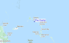
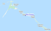
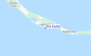
de galerijContourlijnen: Wegen & Rivieren: Kies een surflokatie uit het menu 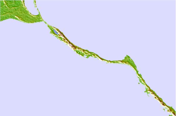
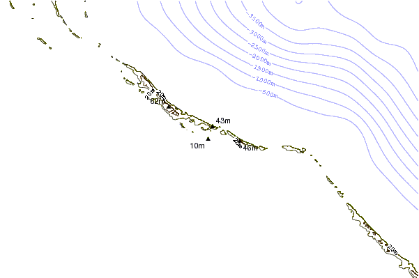
Gebruik deze reliëfkaart om naar de surfspots en de getijdenstations van Eleuthera toe te gaan, in de buurt van The Dump.
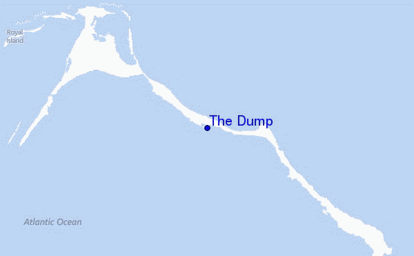
Andere Dichtbijzijnde Surflocaties van The Dump:
(klik op locatienaam voor meer informatie)- Closest Locatie1 mi
- Second closest Locatie1 mi
- Third closest Locatie3 mi
- Fourth closest Locatie4 mi
- Fifth closest Locatie7 mi
Dichtstbijzijnde golfboeien bij The Dump:
- Closest golfboei275 mi
- Second closest golfboei277 mi
- Third closest golfboei316 mi
- Fourth closest golfboei327 mi
- Fifth closest golfboei339 mi
Getijdenstations in de buurt van The Dump:
- Closest getijdenstationEleuthera Island (west coast)12 mi
- Second closest getijdenstationEleuthera Island (east coast)35 mi
- Third closest getijdenstationNassau, New Providence Island57 mi
- Fourth closest getijdenstationPelican Harbour, Abaco Island78 mi
- Fifth closest getijdenstationMarsh Harbour89 mi
Airports
- The closest passenger airport to The Dump is Governors Harbour (Governor's Harbor) Airport (GHB) in Bahamas, 17 km (11 miles) away (directly).
- The second nearest airport to The Dump is North Eleuthera Airport (ELH), also in Bahamas, 25 km (16 miles) away.
- Third is Rock Sound Airport (RSD) in Bahamas, 59 km (37 miles) away.
- Nassau International Airport (NAS) in Bahamas is 104 km (65 miles) away.
- Chub Cay Airport (CCZ), also in Bahamas is the fifth nearest airport to The Dump and is 141 km (88 miles) away.
- /breaks/The-Dump_2/forecasts/latest


 Nearest