

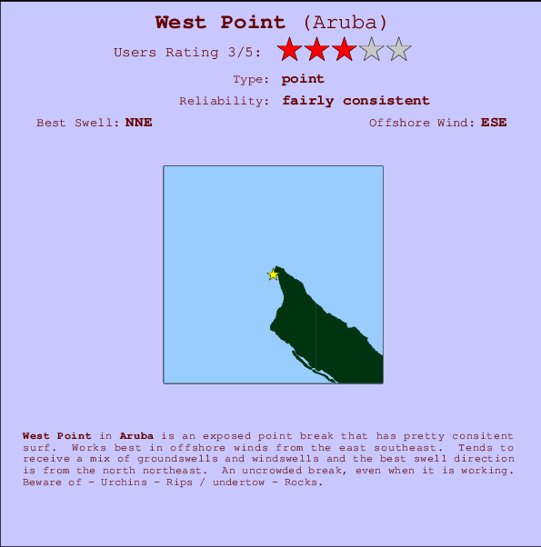
West Point Surf Guide
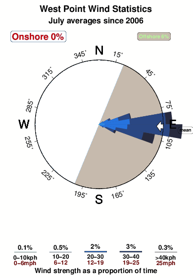
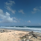
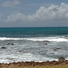
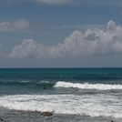
West Point in Aruba is an exposed point break that has reasonably consistent surf. Offshore winds blow from the east southeast. Waves just as likely from local windswells as from distant groundswells and the optimum swell angle is from the north northeast. An uncrowded break, even when it is working. Beware of - Urchins - Rips / undertow - Rocks.
West Point Spot Info
| Type: | Rating: | Reliability: | Todays Sea Temp*: |
|---|---|---|---|
| fairly consistent | 27.8°C*ocean temperature recorded from satellite |
Surfing West Point:
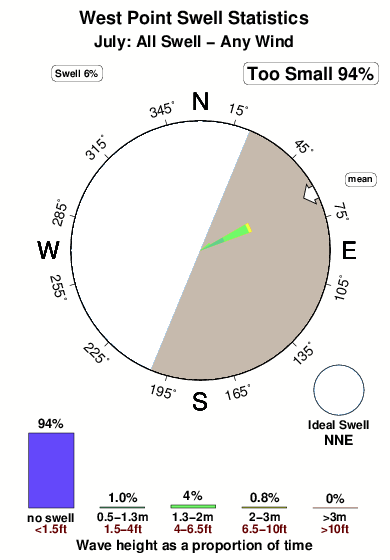
The best conditions reported for surf at West Point occur when a North-northeast swell combines with an offshore wind direction from the East-southeast.
Voorspelde Golfenergie (Kracht): 12 uur

West Point Surf:
Wednesday, 15 July 2026, 05:52 Local time| Wednesday 15 | ||||
| 5AM | 8AM | 11AM | 2PM | |
| Wave (m) | ||||
| Periode (s) | - | - | - | - |
| Wind (km/h) | ||||
| Wind | off | off | off | off |
- /breaks/West-Point-Aruba/forecasts/latest
West Point Surf Guide
West Point in Aruba is an exposed point break that has reasonably consistent surf. Offshore winds blow from the east southeast. Waves just as likely from local windswells as from distant groundswells and the optimum swell angle is from the north northeast. An uncrowded break, even when it is working. Beware of - Urchins - Rips / undertow - Rocks.
West Point Spot Info
Type: Rating: Reliability: Todays Sea Temp*:  Point
Point 3
3fairly consistent 27.8°C*ocean temperature recorded from satelliteSurfing West Point:
The best conditions reported for surf at West Point occur when a North-northeast swell combines with an offshore wind direction from the East-southeast.
Voorspelde Golfenergie (Kracht): 12 uur
Gebruik de tabbladen hierboven om de zeewatertemperatuur bij West Point te bekijken, foto's van West Point, West Point gedetailleerde golfvoorspellingen, wind- en weersvoorspellingen, West Point webcams, actuele wind in Aruba live weerstations en West Point getijdenvoorspellingen. De link van Aruba golfkaarten opent een grote afbeelding van Aruba en de omliggende zeeën. Deze golfkaarten kunnen worden dynamisch gemaakt worden met de verschillende golfcomponenten, golfenergie, golfperiode, golfhoogte, samen met de wind en weersvoorspellingen, het actuele weer en de zeetoestand volgens golfboeien uit Aruba, langskomende schepen en weerstations op de kust. Elk voorspelling pagina's voor dit surfstrand zijn voorzien van een wereldwijde en regionale golfzoeker om de beste surfsomstandigheden in het gebied rond West Point te vinden.
West Point Surf:
Wednesday, 15 July 2026, 05:52 Local timeWednesday 15 5AM 8AM 11AM 2PM Wave (m) Periode (s) - - - - Wind (km/h) Wind off off off off - /breaks/West-Point-Aruba/forecasts/latest
- /breaks/West-Point-Aruba/forecasts/latest/six_day
West Point Surf Guide
West Point in Aruba is an exposed point break that has reasonably consistent surf. Offshore winds blow from the east southeast. Waves just as likely from local windswells as from distant groundswells and the optimum swell angle is from the north northeast. An uncrowded break, even when it is working. Beware of - Urchins - Rips / undertow - Rocks.
West Point Spot Info
Type: Rating: Reliability: Todays Sea Temp*: Point3fairly consistent 27.8°C*ocean temperature recorded from satelliteSurfing West Point:
The best conditions reported for surf at West Point occur when a North-northeast swell combines with an offshore wind direction from the East-southeast.
Voorspelde Golfenergie (Kracht): 12 uur
Gebruik de tabbladen hierboven om de zeewatertemperatuur bij West Point te bekijken, foto's van West Point, West Point gedetailleerde golfvoorspellingen, wind- en weersvoorspellingen, West Point webcams, actuele wind in Aruba live weerstations en West Point getijdenvoorspellingen. De link van Aruba golfkaarten opent een grote afbeelding van Aruba en de omliggende zeeën. Deze golfkaarten kunnen worden dynamisch gemaakt worden met de verschillende golfcomponenten, golfenergie, golfperiode, golfhoogte, samen met de wind en weersvoorspellingen, het actuele weer en de zeetoestand volgens golfboeien uit Aruba, langskomende schepen en weerstations op de kust. Elk voorspelling pagina's voor dit surfstrand zijn voorzien van een wereldwijde en regionale golfzoeker om de beste surfsomstandigheden in het gebied rond West Point te vinden.
West Point Surf:
Wednesday, 15 July 2026, 05:52 Local timeWednesday 15 5AM 8AM 11AM 2PM Wave (m) Periode (s) - - - - Wind (km/h) Wind off off off off - /breaks/West-Point-Aruba/forecasts/latest
West Point Surf Guide
West Point in Aruba is an exposed point break that has reasonably consistent surf. Offshore winds blow from the east southeast. Waves just as likely from local windswells as from distant groundswells and the optimum swell angle is from the north northeast. An uncrowded break, even when it is working. Beware of - Urchins - Rips / undertow - Rocks.
West Point Spot Info
Type: Rating: Reliability: Todays Sea Temp*: Point3fairly consistent 27.8°C*ocean temperature recorded from satelliteSurfing West Point:
The best conditions reported for surf at West Point occur when a North-northeast swell combines with an offshore wind direction from the East-southeast.
Voorspelde Golfenergie (Kracht): 12 uur
Gebruik de tabbladen hierboven om de zeewatertemperatuur bij West Point te bekijken, foto's van West Point, West Point gedetailleerde golfvoorspellingen, wind- en weersvoorspellingen, West Point webcams, actuele wind in Aruba live weerstations en West Point getijdenvoorspellingen. De link van Aruba golfkaarten opent een grote afbeelding van Aruba en de omliggende zeeën. Deze golfkaarten kunnen worden dynamisch gemaakt worden met de verschillende golfcomponenten, golfenergie, golfperiode, golfhoogte, samen met de wind en weersvoorspellingen, het actuele weer en de zeetoestand volgens golfboeien uit Aruba, langskomende schepen en weerstations op de kust. Elk voorspelling pagina's voor dit surfstrand zijn voorzien van een wereldwijde en regionale golfzoeker om de beste surfsomstandigheden in het gebied rond West Point te vinden.
West Point Surf:
Wednesday, 15 July 2026, 05:52 Local timeWednesday 15 5AM 8AM 11AM 2PM Wave (m) Periode (s) - - - - Wind (km/h) Wind off off off off Tide Times:
Voor Arasji, %{dist} %{km} van %{location}.
VOLGENDE IS OM (lokale tijd) resterende tijd hoog water laag water West Point Tide Times and Tide Chart
Live Weather:
At Queen Beatrix Airport, 15 km from West Point.
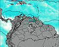
fresh winds from the E
(km/h)Air temperature
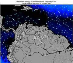
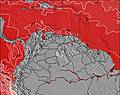
27°COverall West Point Surf Consistency and Wind Distribution in July
surffoto's uit
de galerijContourlijnen: Wegen & Rivieren: Kies een surflokatie uit het menu 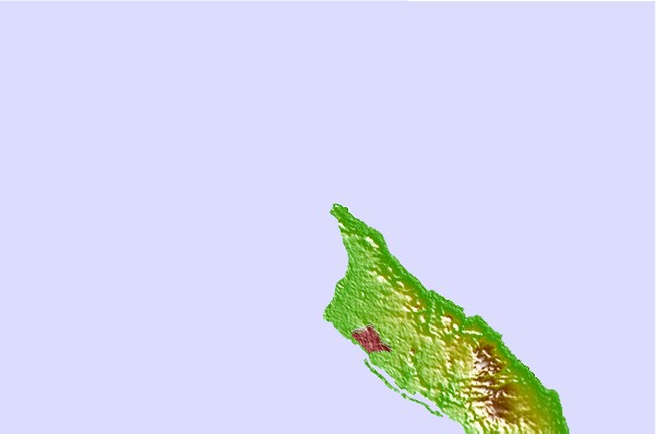
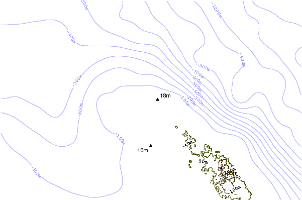
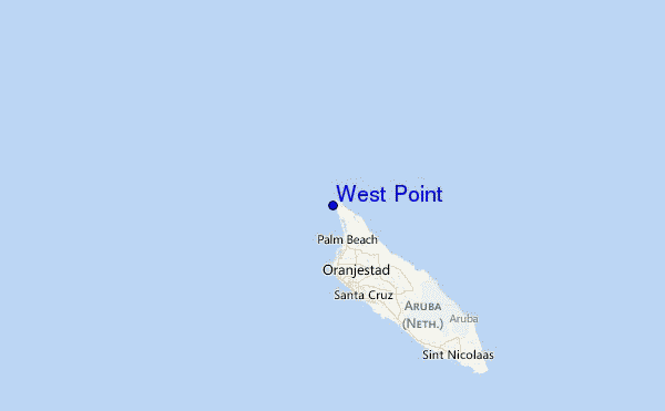
Gebruik deze reliëfkaart om naar de surfspots en de getijdenstations van Aruba toe te gaan, in de buurt van West Point.
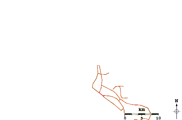
Andere Dichtbijzijnde Surflocaties van West Point:
(klik op locatienaam voor meer informatie)- Closest Locatie1 mi
- Second closest Locatie1 mi
- Third closest Locatie1 mi
- Fourth closest Locatie3 mi
- Fifth closest Locatie5 mi
Dichtstbijzijnde golfboeien bij West Point:
- Closest golfboei433 mi
- Second closest golfboei439 mi
- Third closest golfboei483 mi
- Fourth closest golfboei496 mi
- Fifth closest golfboei515 mi
Getijdenstations in de buurt van West Point:
- Closest getijdenstationArasji1 mi
- Second closest getijdenstationBabijn7 mi
- Third closest getijdenstationAngochi10 mi
- Fourth closest getijdenstationOranjestad10 mi
- Fifth closest getijdenstationAmuay61 mi
Airports
- The closest passenger airport to West Point is Reina Beatrix International (Oranjestad) Airport (AUA) in Aruba, 14 km (9 miles) away (directly).
- The second nearest airport to West Point is Josefa Camejo (Paraguana) Airport (LSP) in Venezuela, 94 km (58 miles) away.
- Third is Hato (Willemstad) Airport (CUR) in Antilles, 129 km (80 miles) away.
- Jose Leonardo Chirinos (Coro) Airport (CZE) in Venezuela is 140 km (87 miles) away.
- Flamingo (Kralendijk) Airport (BON) in Antilles is the fifth nearest airport to West Point and is 202 km (125 miles) away.
- /breaks/West-Point-Aruba/forecasts/latest


 Nearest