
Whaler Island Surf Guide
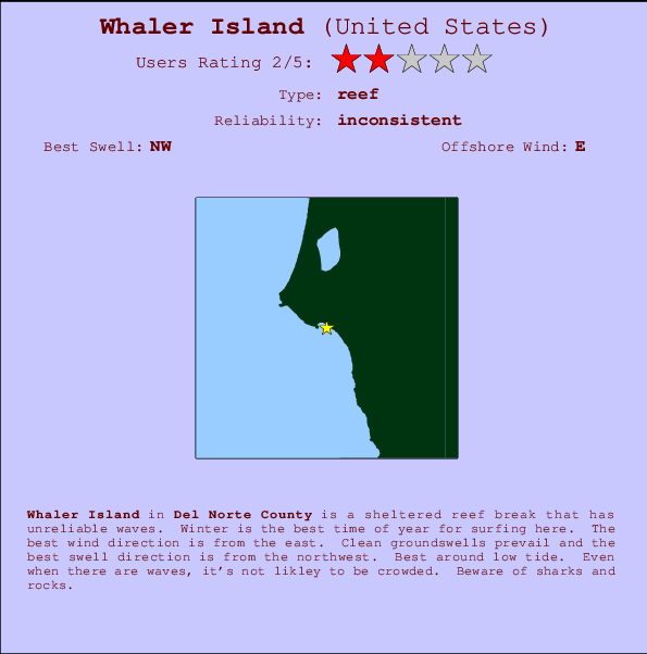
Whaler Island in Del Norte County is a sheltered reef break that has inconsistent surf. Winter is the best time of year for surfing here. Offshore winds are from the east. Most of the surf here comes from groundswells and the optimum swell angle is from the northwest. A right hand reef break. Best around low tide. Unlikely to be too crowded, even when the surf is up. Watch out for sharks and rocks.
Whaler Island Spot Info
| Type: | Rating: | Reliability: | Todays Sea Temp*: |
|---|---|---|---|
| inconsistent | 13.4°C*ocean temperature recorded from satellite |
Surfing Whaler Island:
The best conditions reported for surf at Whaler Island occur when a Northwest swell combines with an offshore wind direction from the East.

Voorspelde Golfenergie (Kracht): 12 uur


Whaler Island Surf:
Wednesday, 15 July 2026, 22:25 Local time| Wednesday 15 | ||||
| 2PM | 5PM | 8PM | 11PM | |
| Wave (m) | ||||
| Periode (s) | 18 | 20 | 6 | 9 |
| Wind (km/h) | ||||
| Wind | cross- on |
cross- on |
cross- on |
cross |
- /breaks/Whaler-Island/forecasts/latest
Whaler Island Surf Guide
Whaler Island in Del Norte County is a sheltered reef break that has inconsistent surf. Winter is the best time of year for surfing here. Offshore winds are from the east. Most of the surf here comes from groundswells and the optimum swell angle is from the northwest. A right hand reef break. Best around low tide. Unlikely to be too crowded, even when the surf is up. Watch out for sharks and rocks.
Whaler Island Spot Info
Type: Rating: Reliability: Todays Sea Temp*:  Reef
Reef 2
2inconsistent 13.4°C*ocean temperature recorded from satelliteSurfing Whaler Island:
The best conditions reported for surf at Whaler Island occur when a Northwest swell combines with an offshore wind direction from the East.
Voorspelde Golfenergie (Kracht): 12 uur
Gebruik de tabbladen hierboven om de zeewatertemperatuur bij Whaler Island te bekijken, foto's van Whaler Island, Whaler Island gedetailleerde golfvoorspellingen, wind- en weersvoorspellingen, Whaler Island webcams, actuele wind in CAL - Del Norte County live weerstations en Whaler Island getijdenvoorspellingen. De link van United States golfkaarten opent een grote afbeelding van United States en de omliggende zeeën. Deze golfkaarten kunnen worden dynamisch gemaakt worden met de verschillende golfcomponenten, golfenergie, golfperiode, golfhoogte, samen met de wind en weersvoorspellingen, het actuele weer en de zeetoestand volgens golfboeien uit United States, langskomende schepen en weerstations op de kust. Elk voorspelling pagina's voor dit surfstrand zijn voorzien van een wereldwijde en regionale golfzoeker om de beste surfsomstandigheden in het gebied rond Whaler Island te vinden.
Whaler Island Surf:
Wednesday, 15 July 2026, 22:25 Local timeWednesday 15 2PM 5PM 8PM 11PM Wave (m) Periode (s) 18 20 6 9 Wind (km/h) Wind cross-
oncross-
oncross-
oncross - /breaks/Whaler-Island/forecasts/latest
- /breaks/Whaler-Island/forecasts/latest/six_day
Whaler Island Surf Guide
Whaler Island in Del Norte County is a sheltered reef break that has inconsistent surf. Winter is the best time of year for surfing here. Offshore winds are from the east. Most of the surf here comes from groundswells and the optimum swell angle is from the northwest. A right hand reef break. Best around low tide. Unlikely to be too crowded, even when the surf is up. Watch out for sharks and rocks.
Whaler Island Spot Info
Type: Rating: Reliability: Todays Sea Temp*: Reef2inconsistent 13.4°C*ocean temperature recorded from satelliteSurfing Whaler Island:
The best conditions reported for surf at Whaler Island occur when a Northwest swell combines with an offshore wind direction from the East.
Voorspelde Golfenergie (Kracht): 12 uur
Gebruik de tabbladen hierboven om de zeewatertemperatuur bij Whaler Island te bekijken, foto's van Whaler Island, Whaler Island gedetailleerde golfvoorspellingen, wind- en weersvoorspellingen, Whaler Island webcams, actuele wind in CAL - Del Norte County live weerstations en Whaler Island getijdenvoorspellingen. De link van United States golfkaarten opent een grote afbeelding van United States en de omliggende zeeën. Deze golfkaarten kunnen worden dynamisch gemaakt worden met de verschillende golfcomponenten, golfenergie, golfperiode, golfhoogte, samen met de wind en weersvoorspellingen, het actuele weer en de zeetoestand volgens golfboeien uit United States, langskomende schepen en weerstations op de kust. Elk voorspelling pagina's voor dit surfstrand zijn voorzien van een wereldwijde en regionale golfzoeker om de beste surfsomstandigheden in het gebied rond Whaler Island te vinden.
Whaler Island Surf:
Wednesday, 15 July 2026, 22:25 Local timeWednesday 15 2PM 5PM 8PM 11PM Wave (m) Periode (s) 18 20 6 9 Wind (km/h) Wind cross-
oncross-
oncross-
oncross - /breaks/Whaler-Island/forecasts/latest
Whaler Island Surf Guide
Whaler Island in Del Norte County is a sheltered reef break that has inconsistent surf. Winter is the best time of year for surfing here. Offshore winds are from the east. Most of the surf here comes from groundswells and the optimum swell angle is from the northwest. A right hand reef break. Best around low tide. Unlikely to be too crowded, even when the surf is up. Watch out for sharks and rocks.
Whaler Island Spot Info
Type: Rating: Reliability: Todays Sea Temp*: Reef2inconsistent 13.4°C*ocean temperature recorded from satelliteSurfing Whaler Island:
The best conditions reported for surf at Whaler Island occur when a Northwest swell combines with an offshore wind direction from the East.
Voorspelde Golfenergie (Kracht): 12 uur
Gebruik de tabbladen hierboven om de zeewatertemperatuur bij Whaler Island te bekijken, foto's van Whaler Island, Whaler Island gedetailleerde golfvoorspellingen, wind- en weersvoorspellingen, Whaler Island webcams, actuele wind in CAL - Del Norte County live weerstations en Whaler Island getijdenvoorspellingen. De link van United States golfkaarten opent een grote afbeelding van United States en de omliggende zeeën. Deze golfkaarten kunnen worden dynamisch gemaakt worden met de verschillende golfcomponenten, golfenergie, golfperiode, golfhoogte, samen met de wind en weersvoorspellingen, het actuele weer en de zeetoestand volgens golfboeien uit United States, langskomende schepen en weerstations op de kust. Elk voorspelling pagina's voor dit surfstrand zijn voorzien van een wereldwijde en regionale golfzoeker om de beste surfsomstandigheden in het gebied rond Whaler Island te vinden.
Whaler Island Surf:
Wednesday, 15 July 2026, 22:25 Local timeWednesday 15 2PM 5PM 8PM 11PM Wave (m) Periode (s) 18 20 6 9 Wind (km/h) Wind cross-
oncross-
oncross-
oncross Tide Times:
Op Crescent City, California (0 km).
VOLGENDE IS OM (lokale tijd) resterende tijd hoog water laag water Whaler Island Tide Times and Tide Chart
Live Weather:
At BUOY-CECC1, 1 km from Whaler Island.
light winds from the N
(km/h)Air temperature
13.7°CCurrent weather near Whaler Island
Buoy Data:
At St Georges Buoy, 12 miles from Whaler Island.
4PM 5PM 6PM 7PM Gegevens Leeftijd 5 hr 4 hr 3 hr 2 hr Golfhoogte (m) 


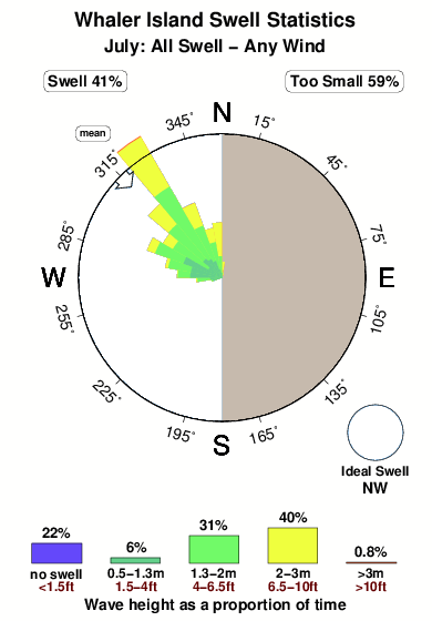
Dominante Periode (s) 9 5 - 6 Overall Whaler Island Surf Consistency and Wind Distribution in July
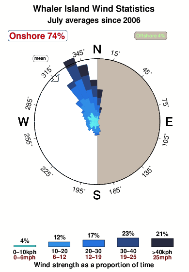


Wind stats for Whaler Island: see the variation in direction and stength by month.
surffoto's uit
de galerijContourlijnen: Wegen & Rivieren: Kies een surflokatie uit het menu 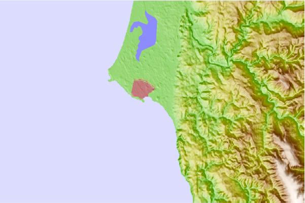
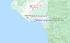
Gebruik deze reliëfkaart om naar de surfspots en de getijdenstations van CAL - Del Norte County toe te gaan, in de buurt van Whaler Island.
Andere Dichtbijzijnde Surflocaties van Whaler Island:
(klik op locatienaam voor meer informatie)- Closest Locatie1 mi
- Second closest Locatie2 mi
- Third closest Locatie4 mi
- Fourth closest Locatie5 mi
- Fifth closest Locatie11 mi
Dichtstbijzijnde golfboeien bij Whaler Island:
- Closest golfboei12 mi
- Second closest golfboei59 mi
- Third closest golfboei72 mi
- Fourth closest golfboei77 mi
- Fifth closest golfboei104 mi
Getijdenstations in de buurt van Whaler Island:
- Closest getijdenstationCrescent City0 mi
- Second closest getijdenstationBrookings, Chetco Cove22 mi
- Third closest getijdenstationTrinidad Harbor48 mi
- Fourth closest getijdenstationWedderburn, Rogue River49 mi
- Fifth closest getijdenstationMcKinleyville55 mi
Airports
- The nearest passenger airport to Whaler Island is Chico Muni Airport (CIC) in USA, which is 292 km (181 miles) away (directly).
- The second closest airport to Whaler Island is Beale Afb (Marysville) Airport (BAB), also in USA, 372 km (231 miles) away.
- /breaks/Whaler-Island/forecasts/latest

 Nearest