
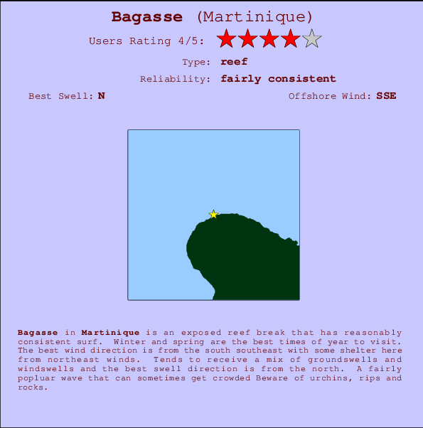
Bagasse Surf Guide
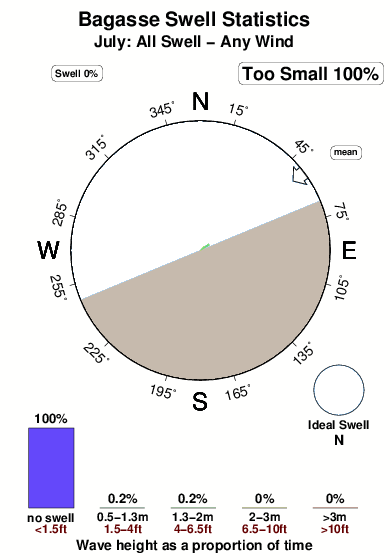
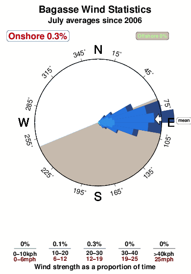
Bagasse on the North Coast is an exposed reef break that has pretty consitent surf. Winter and spring are the best times of year to visit. Offshore winds blow from the south southeast with some shelter here from northeast winds. Tends to receive a mix of groundswells and windswells and the ideal swell direction is from the north. A choice of left and right reefs. It's sometimes crowded here. Take care of urchins, rips and rocks.
Bagasse Spot Info
| Type: | Rating: | Reliability: | Todays Sea Temp*: |
|---|---|---|---|
| fairly consistent | 28.1°C*ocean temperature recorded from satellite |
Surfing Bagasse:
The best conditions reported for surf at Bagasse occur when a North swell combines with an offshore wind direction from the South-southeast.

Voorspelde Golfenergie (Kracht): 12 uur


Bagasse Surf:
Thursday, 16 July 2026, 01:46 Local time| Wednesday 15 | Thu | |||
| 5PM | 8PM | 11PM | 2AM | |
| Wave (m) | ||||
| Periode (s) | 7 | 7 | 7 | 7 |
| Wind (km/h) | ||||
| Wind | cross | cross | cross- off |
cross- off |
- /breaks/Bagasse/forecasts/latest
Bagasse Surf Guide
Bagasse on the North Coast is an exposed reef break that has pretty consitent surf. Winter and spring are the best times of year to visit. Offshore winds blow from the south southeast with some shelter here from northeast winds. Tends to receive a mix of groundswells and windswells and the ideal swell direction is from the north. A choice of left and right reefs. It's sometimes crowded here. Take care of urchins, rips and rocks.
Bagasse Spot Info
Type: Rating: Reliability: Todays Sea Temp*:  Reef
Reef 4
4fairly consistent 28.1°C*ocean temperature recorded from satelliteSurfing Bagasse:
The best conditions reported for surf at Bagasse occur when a North swell combines with an offshore wind direction from the South-southeast.
Voorspelde Golfenergie (Kracht): 12 uur
Gebruik de tabbladen hierboven om de zeewatertemperatuur bij Bagasse te bekijken, foto's van Bagasse, Bagasse gedetailleerde golfvoorspellingen, wind- en weersvoorspellingen, Bagasse webcams, actuele wind in Martinique live weerstations en Bagasse getijdenvoorspellingen. De link van Martinique golfkaarten opent een grote afbeelding van Martinique en de omliggende zeeën. Deze golfkaarten kunnen worden dynamisch gemaakt worden met de verschillende golfcomponenten, golfenergie, golfperiode, golfhoogte, samen met de wind en weersvoorspellingen, het actuele weer en de zeetoestand volgens golfboeien uit Martinique, langskomende schepen en weerstations op de kust. Elk voorspelling pagina's voor dit surfstrand zijn voorzien van een wereldwijde en regionale golfzoeker om de beste surfsomstandigheden in het gebied rond Bagasse te vinden.
Bagasse Surf:
Thursday, 16 July 2026, 01:46 Local timeWednesday 15 Thu 5PM 8PM 11PM 2AM Wave (m) Periode (s) 7 7 7 7 Wind (km/h) Wind cross cross cross-
offcross-
off- /breaks/Bagasse/forecasts/latest
- /breaks/Bagasse/forecasts/latest/six_day
Bagasse Surf Guide
Bagasse on the North Coast is an exposed reef break that has pretty consitent surf. Winter and spring are the best times of year to visit. Offshore winds blow from the south southeast with some shelter here from northeast winds. Tends to receive a mix of groundswells and windswells and the ideal swell direction is from the north. A choice of left and right reefs. It's sometimes crowded here. Take care of urchins, rips and rocks.
Bagasse Spot Info
Type: Rating: Reliability: Todays Sea Temp*: Reef4fairly consistent 28.1°C*ocean temperature recorded from satelliteSurfing Bagasse:
The best conditions reported for surf at Bagasse occur when a North swell combines with an offshore wind direction from the South-southeast.
Voorspelde Golfenergie (Kracht): 12 uur
Gebruik de tabbladen hierboven om de zeewatertemperatuur bij Bagasse te bekijken, foto's van Bagasse, Bagasse gedetailleerde golfvoorspellingen, wind- en weersvoorspellingen, Bagasse webcams, actuele wind in Martinique live weerstations en Bagasse getijdenvoorspellingen. De link van Martinique golfkaarten opent een grote afbeelding van Martinique en de omliggende zeeën. Deze golfkaarten kunnen worden dynamisch gemaakt worden met de verschillende golfcomponenten, golfenergie, golfperiode, golfhoogte, samen met de wind en weersvoorspellingen, het actuele weer en de zeetoestand volgens golfboeien uit Martinique, langskomende schepen en weerstations op de kust. Elk voorspelling pagina's voor dit surfstrand zijn voorzien van een wereldwijde en regionale golfzoeker om de beste surfsomstandigheden in het gebied rond Bagasse te vinden.
Bagasse Surf:
Thursday, 16 July 2026, 01:46 Local timeWednesday 15 Thu 5PM 8PM 11PM 2AM Wave (m) Periode (s) 7 7 7 7 Wind (km/h) Wind cross cross cross-
offcross-
off- /breaks/Bagasse/forecasts/latest
Bagasse Surf Guide
Bagasse on the North Coast is an exposed reef break that has pretty consitent surf. Winter and spring are the best times of year to visit. Offshore winds blow from the south southeast with some shelter here from northeast winds. Tends to receive a mix of groundswells and windswells and the ideal swell direction is from the north. A choice of left and right reefs. It's sometimes crowded here. Take care of urchins, rips and rocks.
Bagasse Spot Info
Type: Rating: Reliability: Todays Sea Temp*: Reef4fairly consistent 28.1°C*ocean temperature recorded from satelliteSurfing Bagasse:
The best conditions reported for surf at Bagasse occur when a North swell combines with an offshore wind direction from the South-southeast.
Voorspelde Golfenergie (Kracht): 12 uur
Gebruik de tabbladen hierboven om de zeewatertemperatuur bij Bagasse te bekijken, foto's van Bagasse, Bagasse gedetailleerde golfvoorspellingen, wind- en weersvoorspellingen, Bagasse webcams, actuele wind in Martinique live weerstations en Bagasse getijdenvoorspellingen. De link van Martinique golfkaarten opent een grote afbeelding van Martinique en de omliggende zeeën. Deze golfkaarten kunnen worden dynamisch gemaakt worden met de verschillende golfcomponenten, golfenergie, golfperiode, golfhoogte, samen met de wind en weersvoorspellingen, het actuele weer en de zeetoestand volgens golfboeien uit Martinique, langskomende schepen en weerstations op de kust. Elk voorspelling pagina's voor dit surfstrand zijn voorzien van een wereldwijde en regionale golfzoeker om de beste surfsomstandigheden in het gebied rond Bagasse te vinden.
Bagasse Surf:
Thursday, 16 July 2026, 01:46 Local timeWednesday 15 Thu 5PM 8PM 11PM 2AM Wave (m) Periode (s) 7 7 7 7 Wind (km/h) Wind cross cross cross-
offcross-
offTide Times:
Voor Anse Couleuvre, %{dist} %{km} van %{location}.
VOLGENDE IS OM (lokale tijd) resterende tijd hoog water laag water Bagasse Tide Times and Tide Chart
Live Weather:
At Rhum JM, 5 km from Bagasse.
wind obs. (15 kph from 191 degs) was rejected
(km/h)Air temperature
25.0°COverall Bagasse Surf Consistency and Wind Distribution in July
surffoto's uit
de galerijContourlijnen: Wegen & Rivieren: Kies een surflokatie uit het menu 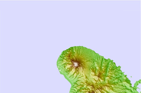
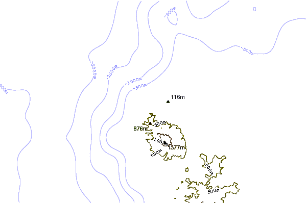
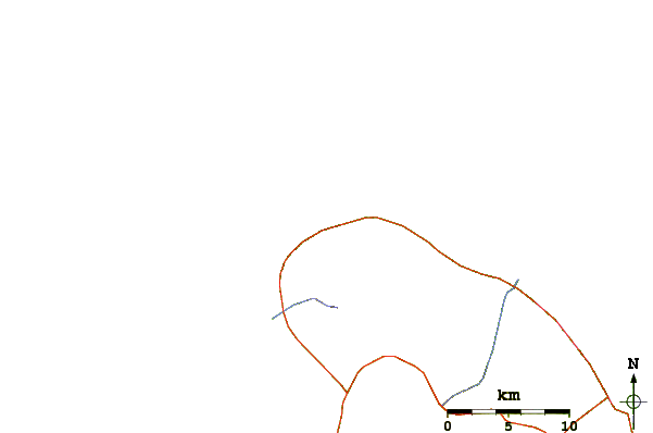
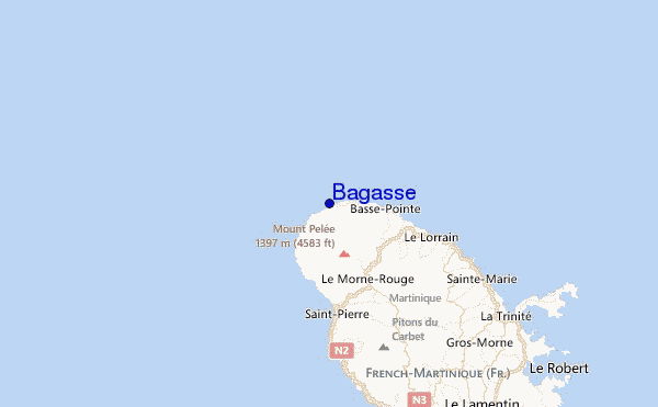
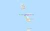
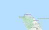
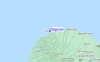
Gebruik deze reliëfkaart om naar de surfspots en de getijdenstations van Martinique toe te gaan, in de buurt van Bagasse.
Andere Dichtbijzijnde Surflocaties van Bagasse:
(klik op locatienaam voor meer informatie)- Closest Locatie1 mi
- Second closest Locatie2 mi
- Third closest Locatie4 mi
- Fourth closest Locatie4 mi
- Fifth closest Locatie4 mi
Dichtstbijzijnde golfboeien bij Bagasse:
- Closest golfboei191 mi
- Second closest golfboei333 mi
- Third closest golfboei334 mi
- Fourth closest golfboei367 mi
- Fifth closest golfboei410 mi
Getijdenstations in de buurt van Bagasse:
- Closest getijdenstationLe Lorrain9 mi
- Second closest getijdenstationSainte-Marie15 mi
- Third closest getijdenstationPetite Riviere Salee17 mi
- Fourth closest getijdenstationLa Trinite17 mi
- Fifth closest getijdenstationLe Robert21 mi
Airports
- The closest passenger airport to Bagasse is Le Lamentin (Fort-de-france) Airport (FDF) in Antilles, 37 km (23 miles) away (directly).
- The second nearest airport to Bagasse is Canefield Airport (DCF) in Dominica, 56 km (35 miles) away.
- Third is Melville Hall (Dominica) Airport (DOM) in Dominica, 76 km (47 miles) away.
- George F L Charles (Castries) Airport (SLU) in St. Lucia Island is 97 km (60 miles) away.
- Hewanorra International (Hewandorra) Airport (UVF), also in St. Lucia Island is the fifth nearest airport to Bagasse and is 129 km (80 miles) away.
- /breaks/Bagasse/forecasts/latest

 Nearest