
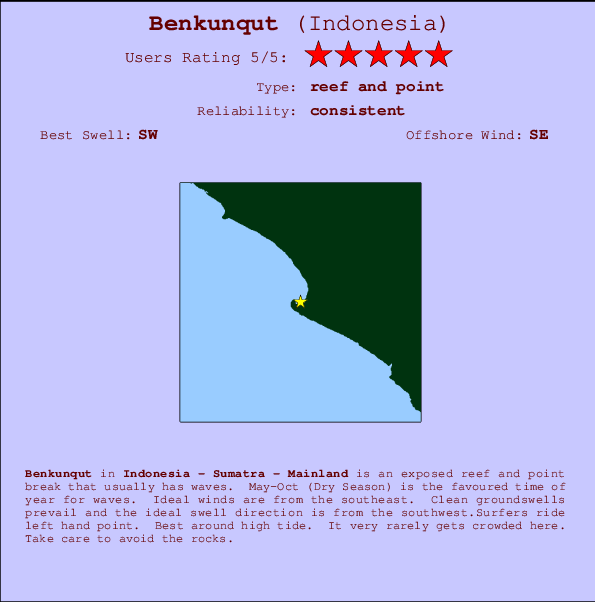
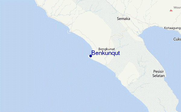
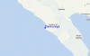
Benkunqut Surf Guide
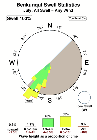
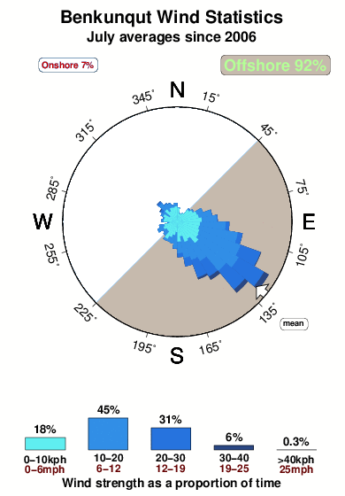
Benkunqut in Sumatra is an exposed reef and point break that has consistent surf. May-Oct (Dry Season) is the best time of year for waves. Offshore winds are from the southeast. Groundswells more frequent than windswells and the optimum swell angle is from the southwest.The waves is a point break that peels left. Best around high tide. Even when there are waves, it's not likley to be crowded. Watch out for rocks.
Benkunqut Spot Info
| Type: | Rating: | Reliability: | Todays Sea Temp*: |
|---|---|---|---|
| consistent | 29.1°C*ocean temperature recorded from satellite |
Surfing Benkunqut:
The best conditions reported for surf at Benkunqut occur when a Southwest swell combines with an offshore wind direction from the Southeast.

Voorspelde Golfenergie (Kracht): 12 uur


Benkunqut Surf:
Wednesday, 15 July 2026, 15:17 Local time| Wednesday 15 | ||||
| 10AM | 1PM | 4PM | 7PM | |
| Wave (m) | ||||
| Periode (s) | 16 | 16 | 16 | 15 |
| Wind (km/h) | ||||
| Wind | cross- off |
off | off | off |
- /breaks/Benkunqut/forecasts/latest
Benkunqut Surf Guide
Benkunqut in Sumatra is an exposed reef and point break that has consistent surf. May-Oct (Dry Season) is the best time of year for waves. Offshore winds are from the southeast. Groundswells more frequent than windswells and the optimum swell angle is from the southwest.The waves is a point break that peels left. Best around high tide. Even when there are waves, it's not likley to be crowded. Watch out for rocks.
Benkunqut Spot Info
Type: Rating: Reliability: Todays Sea Temp*:  Reef and point
 5
5consistent 29.1°C*ocean temperature recorded from satelliteSurfing Benkunqut:
The best conditions reported for surf at Benkunqut occur when a Southwest swell combines with an offshore wind direction from the Southeast.
Voorspelde Golfenergie (Kracht): 12 uur
Gebruik de tabbladen hierboven om de zeewatertemperatuur bij Benkunqut te bekijken, foto's van Benkunqut, Benkunqut gedetailleerde golfvoorspellingen, wind- en weersvoorspellingen, Benkunqut webcams, actuele wind in Sumatra - Mainland live weerstations en Benkunqut getijdenvoorspellingen. De link van Indonesia golfkaarten opent een grote afbeelding van Indonesia en de omliggende zeeën. Deze golfkaarten kunnen worden dynamisch gemaakt worden met de verschillende golfcomponenten, golfenergie, golfperiode, golfhoogte, samen met de wind en weersvoorspellingen, het actuele weer en de zeetoestand volgens golfboeien uit Indonesia, langskomende schepen en weerstations op de kust. Elk voorspelling pagina's voor dit surfstrand zijn voorzien van een wereldwijde en regionale golfzoeker om de beste surfsomstandigheden in het gebied rond Benkunqut te vinden.
Benkunqut Surf:
Wednesday, 15 July 2026, 15:17 Local timeWednesday 15 10AM 1PM 4PM 7PM Wave (m) Periode (s) 16 16 16 15 Wind (km/h) Wind cross-
offoff off off - /breaks/Benkunqut/forecasts/latest
- /breaks/Benkunqut/forecasts/latest/six_day
Benkunqut Surf Guide
Benkunqut in Sumatra is an exposed reef and point break that has consistent surf. May-Oct (Dry Season) is the best time of year for waves. Offshore winds are from the southeast. Groundswells more frequent than windswells and the optimum swell angle is from the southwest.The waves is a point break that peels left. Best around high tide. Even when there are waves, it's not likley to be crowded. Watch out for rocks.
Benkunqut Spot Info
Type: Rating: Reliability: Todays Sea Temp*: Reef and point5consistent 29.1°C*ocean temperature recorded from satelliteSurfing Benkunqut:
The best conditions reported for surf at Benkunqut occur when a Southwest swell combines with an offshore wind direction from the Southeast.
Voorspelde Golfenergie (Kracht): 12 uur
Gebruik de tabbladen hierboven om de zeewatertemperatuur bij Benkunqut te bekijken, foto's van Benkunqut, Benkunqut gedetailleerde golfvoorspellingen, wind- en weersvoorspellingen, Benkunqut webcams, actuele wind in Sumatra - Mainland live weerstations en Benkunqut getijdenvoorspellingen. De link van Indonesia golfkaarten opent een grote afbeelding van Indonesia en de omliggende zeeën. Deze golfkaarten kunnen worden dynamisch gemaakt worden met de verschillende golfcomponenten, golfenergie, golfperiode, golfhoogte, samen met de wind en weersvoorspellingen, het actuele weer en de zeetoestand volgens golfboeien uit Indonesia, langskomende schepen en weerstations op de kust. Elk voorspelling pagina's voor dit surfstrand zijn voorzien van een wereldwijde en regionale golfzoeker om de beste surfsomstandigheden in het gebied rond Benkunqut te vinden.
Benkunqut Surf:
Wednesday, 15 July 2026, 15:17 Local timeWednesday 15 10AM 1PM 4PM 7PM Wave (m) Periode (s) 16 16 16 15 Wind (km/h) Wind cross-
offoff off off - /breaks/Benkunqut/forecasts/latest
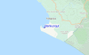
Benkunqut Surf Guide
Benkunqut in Sumatra is an exposed reef and point break that has consistent surf. May-Oct (Dry Season) is the best time of year for waves. Offshore winds are from the southeast. Groundswells more frequent than windswells and the optimum swell angle is from the southwest.The waves is a point break that peels left. Best around high tide. Even when there are waves, it's not likley to be crowded. Watch out for rocks.
Benkunqut Spot Info
Type: Rating: Reliability: Todays Sea Temp*: Reef and point5consistent 29.1°C*ocean temperature recorded from satelliteSurfing Benkunqut:
The best conditions reported for surf at Benkunqut occur when a Southwest swell combines with an offshore wind direction from the Southeast.
Voorspelde Golfenergie (Kracht): 12 uur
Gebruik de tabbladen hierboven om de zeewatertemperatuur bij Benkunqut te bekijken, foto's van Benkunqut, Benkunqut gedetailleerde golfvoorspellingen, wind- en weersvoorspellingen, Benkunqut webcams, actuele wind in Sumatra - Mainland live weerstations en Benkunqut getijdenvoorspellingen. De link van Indonesia golfkaarten opent een grote afbeelding van Indonesia en de omliggende zeeën. Deze golfkaarten kunnen worden dynamisch gemaakt worden met de verschillende golfcomponenten, golfenergie, golfperiode, golfhoogte, samen met de wind en weersvoorspellingen, het actuele weer en de zeetoestand volgens golfboeien uit Indonesia, langskomende schepen en weerstations op de kust. Elk voorspelling pagina's voor dit surfstrand zijn voorzien van een wereldwijde en regionale golfzoeker om de beste surfsomstandigheden in het gebied rond Benkunqut te vinden.
Benkunqut Surf:
Wednesday, 15 July 2026, 15:17 Local timeWednesday 15 10AM 1PM 4PM 7PM Wave (m) Periode (s) 16 16 16 15 Wind (km/h) Wind cross-
offoff off off Tide Times:
Op Benkunqut (0 km).
VOLGENDE IS OM (lokale tijd) resterende tijd hoog water laag water Benkunqut Tide Times and Tide Chart
Live Weather:
At Soekarno-Hatta International Airport, 265 km from Benkunqut.
moderate winds from the NE
(km/h)
Dry and partly cloudyAir temperature
33°COverall Benkunqut Surf Consistency and Wind Distribution in July
surffoto's uit
de galerijContourlijnen: Wegen & Rivieren: Kies een surflokatie uit het menu 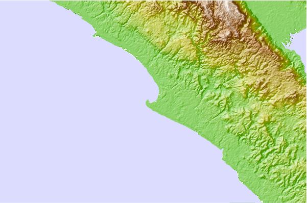
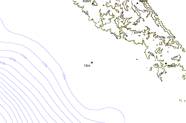
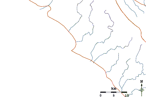
Gebruik deze reliëfkaart om naar de surfspots en de getijdenstations van Sumatra - Mainland toe te gaan, in de buurt van Benkunqut.
Andere Dichtbijzijnde Surflocaties van Benkunqut:
(klik op locatienaam voor meer informatie)- Closest Locatie10 mi
- Second closest Locatie25 mi
- Third closest Locatie26 mi
- Fourth closest Locatie27 mi
- Fifth closest Locatie31 mi
Dichtstbijzijnde golfboeien bij Benkunqut:
- Closest golfboei2466 mi
- Second closest golfboei2534 mi
- Third closest golfboei2594 mi
- Fourth closest golfboei2704 mi
- Fifth closest golfboei2715 mi
Getijdenstations in de buurt van Benkunqut:
- Closest getijdenstationBandar Lampung70 mi
- Second closest getijdenstationLabuhan117 mi
- Third closest getijdenstationJakarta172 mi
- Fourth closest getijdenstationTanjung Priok179 mi
- Fifth closest getijdenstationPelabuhanratu180 mi
Airports
- The nearest passenger airport to Benkunqut is Soekarno Hatta International (Jakarta) Airport (CGK) in Indonesia, which is 266 km (165 miles) away (directly).
- The second closest airport to Benkunqut is Pondok Cabe (Jakarta) Airport (PCB), also in Indonesia, 283 km (176 miles) away.
- /breaks/Benkunqut/forecasts/latest


 Nearest