
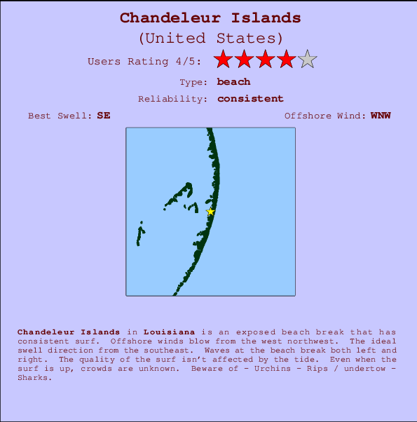
Chandeleur Islands Surf Guide
Chandeleur Islands in Louisiana is an exposed beach break that has reliable surf. The best wind direction is from the west northwest. The optimum well angle is from the southeast. Waves at the beach break both left and right. Good surf at all stages of the tide. The location means that it never gets crowded. Beware of - Urchins - Rips / undertow - Sharks.
Chandeleur Islands Spot Info
| Type: | Rating: | Reliability: | Todays Sea Temp*: |
|---|---|---|---|
| consistent | 30.7°C*ocean temperature recorded from satellite |
Surfing Chandeleur Islands:
The best conditions reported for surf at Chandeleur Islands occur when a Southeast swell combines with an offshore wind direction from the West-northwest.
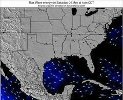
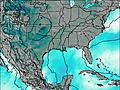
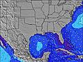
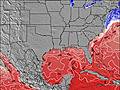
Voorspelde Golfenergie (Kracht): 12 uur
Chandeleur Islands Surf:
Monday, 20 July 2026, 07:19 Local time| Monday 20 | ||||
| 4AM | 7AM | 10AM | 1PM | |
| Wave (m) | ||||
| Periode (s) | 4 | 6 | 6 | 6 |
| Wind (km/h) | ||||
| Wind | cross- off |
cross- off |
cross | cross |
- /breaks/Chandeleur-Islands/forecasts/latest
Chandeleur Islands Surf Guide
Chandeleur Islands in Louisiana is an exposed beach break that has reliable surf. The best wind direction is from the west northwest. The optimum well angle is from the southeast. Waves at the beach break both left and right. Good surf at all stages of the tide. The location means that it never gets crowded. Beware of - Urchins - Rips / undertow - Sharks.
Chandeleur Islands Spot Info
Type: Rating: Reliability: Todays Sea Temp*:  Beach
Beach 4
4consistent 30.7°C*ocean temperature recorded from satelliteSurfing Chandeleur Islands:
The best conditions reported for surf at Chandeleur Islands occur when a Southeast swell combines with an offshore wind direction from the West-northwest.
Voorspelde Golfenergie (Kracht): 12 uur
Gebruik de tabbladen hierboven om de zeewatertemperatuur bij Chandeleur Islands te bekijken, foto's van Chandeleur Islands, Chandeleur Islands gedetailleerde golfvoorspellingen, wind- en weersvoorspellingen, Chandeleur Islands webcams, actuele wind in Louisiana live weerstations en Chandeleur Islands getijdenvoorspellingen. De link van United States golfkaarten opent een grote afbeelding van United States en de omliggende zeeën. Deze golfkaarten kunnen worden dynamisch gemaakt worden met de verschillende golfcomponenten, golfenergie, golfperiode, golfhoogte, samen met de wind en weersvoorspellingen, het actuele weer en de zeetoestand volgens golfboeien uit United States, langskomende schepen en weerstations op de kust. Elk voorspelling pagina's voor dit surfstrand zijn voorzien van een wereldwijde en regionale golfzoeker om de beste surfsomstandigheden in het gebied rond Chandeleur Islands te vinden.
Chandeleur Islands Surf:
Monday, 20 July 2026, 07:19 Local timeMonday 20 4AM 7AM 10AM 1PM Wave (m) Periode (s) 4 6 6 6 Wind (km/h) Wind cross-
offcross-
offcross cross - /breaks/Chandeleur-Islands/forecasts/latest
- /breaks/Chandeleur-Islands/forecasts/latest/six_day
Chandeleur Islands Surf Guide
Chandeleur Islands in Louisiana is an exposed beach break that has reliable surf. The best wind direction is from the west northwest. The optimum well angle is from the southeast. Waves at the beach break both left and right. Good surf at all stages of the tide. The location means that it never gets crowded. Beware of - Urchins - Rips / undertow - Sharks.
Chandeleur Islands Spot Info
Type: Rating: Reliability: Todays Sea Temp*: Beach4consistent 30.7°C*ocean temperature recorded from satelliteSurfing Chandeleur Islands:
The best conditions reported for surf at Chandeleur Islands occur when a Southeast swell combines with an offshore wind direction from the West-northwest.
Voorspelde Golfenergie (Kracht): 12 uur
Gebruik de tabbladen hierboven om de zeewatertemperatuur bij Chandeleur Islands te bekijken, foto's van Chandeleur Islands, Chandeleur Islands gedetailleerde golfvoorspellingen, wind- en weersvoorspellingen, Chandeleur Islands webcams, actuele wind in Louisiana live weerstations en Chandeleur Islands getijdenvoorspellingen. De link van United States golfkaarten opent een grote afbeelding van United States en de omliggende zeeën. Deze golfkaarten kunnen worden dynamisch gemaakt worden met de verschillende golfcomponenten, golfenergie, golfperiode, golfhoogte, samen met de wind en weersvoorspellingen, het actuele weer en de zeetoestand volgens golfboeien uit United States, langskomende schepen en weerstations op de kust. Elk voorspelling pagina's voor dit surfstrand zijn voorzien van een wereldwijde en regionale golfzoeker om de beste surfsomstandigheden in het gebied rond Chandeleur Islands te vinden.
Chandeleur Islands Surf:
Monday, 20 July 2026, 07:19 Local timeMonday 20 4AM 7AM 10AM 1PM Wave (m) Periode (s) 4 6 6 6 Wind (km/h) Wind cross-
offcross-
offcross cross - /breaks/Chandeleur-Islands/forecasts/latest
Chandeleur Islands Surf Guide
Chandeleur Islands in Louisiana is an exposed beach break that has reliable surf. The best wind direction is from the west northwest. The optimum well angle is from the southeast. Waves at the beach break both left and right. Good surf at all stages of the tide. The location means that it never gets crowded. Beware of - Urchins - Rips / undertow - Sharks.
Chandeleur Islands Spot Info
Type: Rating: Reliability: Todays Sea Temp*: Beach4consistent 30.7°C*ocean temperature recorded from satelliteSurfing Chandeleur Islands:
The best conditions reported for surf at Chandeleur Islands occur when a Southeast swell combines with an offshore wind direction from the West-northwest.
Voorspelde Golfenergie (Kracht): 12 uur
Gebruik de tabbladen hierboven om de zeewatertemperatuur bij Chandeleur Islands te bekijken, foto's van Chandeleur Islands, Chandeleur Islands gedetailleerde golfvoorspellingen, wind- en weersvoorspellingen, Chandeleur Islands webcams, actuele wind in Louisiana live weerstations en Chandeleur Islands getijdenvoorspellingen. De link van United States golfkaarten opent een grote afbeelding van United States en de omliggende zeeën. Deze golfkaarten kunnen worden dynamisch gemaakt worden met de verschillende golfcomponenten, golfenergie, golfperiode, golfhoogte, samen met de wind en weersvoorspellingen, het actuele weer en de zeetoestand volgens golfboeien uit United States, langskomende schepen en weerstations op de kust. Elk voorspelling pagina's voor dit surfstrand zijn voorzien van een wereldwijde en regionale golfzoeker om de beste surfsomstandigheden in het gebied rond Chandeleur Islands te vinden.
Chandeleur Islands Surf:
Monday, 20 July 2026, 07:19 Local timeMonday 20 4AM 7AM 10AM 1PM Wave (m) Periode (s) 4 6 6 6 Wind (km/h) Wind cross-
offcross-
offcross cross Tide Times:
Op Chandeleur Islands (0 km).
VOLGENDE IS OM (lokale tijd) resterende tijd hoog water laag water Chandeleur Islands Tide Times and Tide Chart
Live Weather:
At BUOY-42354, 35 km from Chandeleur Islands.
- Air temperature
-°COverall Chandeleur Islands Surf Consistency and Wind Distribution in July


Wind stats for Chandeleur Islands: see the variation in direction and stength by month.
surffoto's uit
de galerijContourlijnen: Wegen & Rivieren: Kies een surflokatie uit het menu 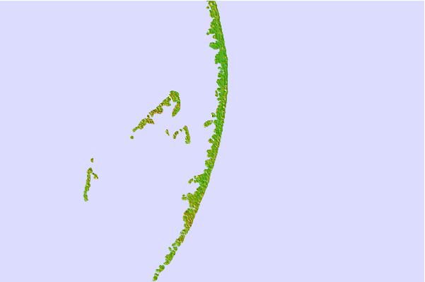

Gebruik deze reliëfkaart om naar de surfspots en de getijdenstations van Louisiana toe te gaan, in de buurt van Chandeleur Islands.
Andere Dichtbijzijnde Surflocaties van Chandeleur Islands:
(klik op locatienaam voor meer informatie)- Closest Locatie53 mi
- Second closest Locatie71 mi
- Third closest Locatie81 mi
- Fourth closest Locatie82 mi
- Fifth closest Locatie83 mi
Dichtstbijzijnde golfboeien bij Chandeleur Islands:
- Closest golfboei17 mi
- Second closest golfboei78 mi
- Third closest golfboei98 mi
- Fourth closest golfboei116 mi
- Fifth closest golfboei120 mi
Getijdenstations in de buurt van Chandeleur Islands:
- Closest getijdenstationChandeleur Light14 mi
- Second closest getijdenstationComfort Island26 mi
- Third closest getijdenstationShip Island Sound27 mi
- Fourth closest getijdenstationShip Island Pass27 mi
- Fifth closest getijdenstationHorn Island Sound29 mi
Airports
- The closest passenger airport to Chandeleur Islands is Keesler Afb (Biloxi) Airport (BIX) in USA, 63 km (39 miles) away (directly).
- The second nearest airport to Chandeleur Islands is Mobile Rgnl Airport (MOB), also in USA, 110 km (68 miles) away.
- Third is Mobile Downtown Airport (BFM) in USA, 114 km (71 miles) away.
- New Orleans Nas Jrb Airport (NBG) in USA is 116 km (72 miles) away.
- Louis Armstrong New Orleans International Airport (MSY), also in USA is the fifth nearest airport to Chandeleur Islands and is 138 km (86 miles) away.
- /breaks/Chandeleur-Islands/forecasts/latest

 Nearest