

Grajagan Bay/G-Land Surf Guide
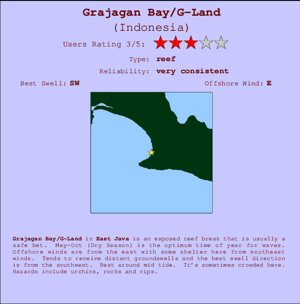
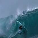
Grajagan Bay/G-Land in East Java is an exposed reef break that has very consistent waves. May-Oct (Dry Season) is the optimum time of year for waves. Offshore winds are from the east with some shelter here from southeast winds. Most of the surf here comes from groundswells and the best swell direction is from the southwest. A left hand reef break. Best around mid tide. When it's working here, it can get crowded. Beware of urchins, rocks and rips.
Grajagan Bay/G-Land Spot Info
| Type: | Rating: | Reliability: | Todays Sea Temp*: |
|---|---|---|---|
| very consistent | 26.1°C*ocean temperature recorded from satellite |
Surfing Grajagan Bay/G-Land:
The best conditions reported for surf at Grajagan Bay/G-Land occur when a Southwest swell combines with an offshore wind direction from the East.

Voorspelde Golfenergie (Kracht): 12 uur


Grajagan Bay/G-Land Surf:
Friday, 17 July 2026, 02:23 Local time| Thu | Friday 17 | |||
| 10PM | 1AM | 4AM | 7AM | |
| Wave (m) | ||||
| Periode (s) | 15 | 14 | 14 | 14 |
| Wind (km/h) | ||||
| Wind | off | off | off | off |
- /breaks/Grajagan-Bay/forecasts/latest
Grajagan Bay/G-Land Surf Guide
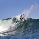
Grajagan Bay/G-Land in East Java is an exposed reef break that has very consistent waves. May-Oct (Dry Season) is the optimum time of year for waves. Offshore winds are from the east with some shelter here from southeast winds. Most of the surf here comes from groundswells and the best swell direction is from the southwest. A left hand reef break. Best around mid tide. When it's working here, it can get crowded. Beware of urchins, rocks and rips.
Grajagan Bay/G-Land Spot Info
Type: Rating: Reliability: Todays Sea Temp*:  Reef
Reef 3
3very consistent 26.1°C*ocean temperature recorded from satelliteSurfing Grajagan Bay/G-Land:
The best conditions reported for surf at Grajagan Bay/G-Land occur when a Southwest swell combines with an offshore wind direction from the East.
Voorspelde Golfenergie (Kracht): 12 uur
Gebruik de tabbladen hierboven om de zeewatertemperatuur bij Grajagan Bay/G-Land te bekijken, foto's van Grajagan Bay/G-Land, Grajagan Bay/G-Land gedetailleerde golfvoorspellingen, wind- en weersvoorspellingen, Grajagan Bay/G-Land webcams, actuele wind in Java - East live weerstations en Grajagan Bay/G-Land getijdenvoorspellingen. De link van Indonesia golfkaarten opent een grote afbeelding van Indonesia en de omliggende zeeën. Deze golfkaarten kunnen worden dynamisch gemaakt worden met de verschillende golfcomponenten, golfenergie, golfperiode, golfhoogte, samen met de wind en weersvoorspellingen, het actuele weer en de zeetoestand volgens golfboeien uit Indonesia, langskomende schepen en weerstations op de kust. Elk voorspelling pagina's voor dit surfstrand zijn voorzien van een wereldwijde en regionale golfzoeker om de beste surfsomstandigheden in het gebied rond Grajagan Bay/G-Land te vinden.
Grajagan Bay/G-Land Surf:
Friday, 17 July 2026, 02:23 Local timeThu Friday 17 10PM 1AM 4AM 7AM Wave (m) Periode (s) 15 14 14 14 Wind (km/h) Wind off off off off - /breaks/Grajagan-Bay/forecasts/latest
- /breaks/Grajagan-Bay/forecasts/latest/six_day
Grajagan Bay/G-Land Surf Guide
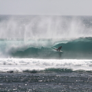
Grajagan Bay/G-Land in East Java is an exposed reef break that has very consistent waves. May-Oct (Dry Season) is the optimum time of year for waves. Offshore winds are from the east with some shelter here from southeast winds. Most of the surf here comes from groundswells and the best swell direction is from the southwest. A left hand reef break. Best around mid tide. When it's working here, it can get crowded. Beware of urchins, rocks and rips.
Grajagan Bay/G-Land Spot Info
Type: Rating: Reliability: Todays Sea Temp*: Reef3very consistent 26.1°C*ocean temperature recorded from satelliteSurfing Grajagan Bay/G-Land:
The best conditions reported for surf at Grajagan Bay/G-Land occur when a Southwest swell combines with an offshore wind direction from the East.
Voorspelde Golfenergie (Kracht): 12 uur
Gebruik de tabbladen hierboven om de zeewatertemperatuur bij Grajagan Bay/G-Land te bekijken, foto's van Grajagan Bay/G-Land, Grajagan Bay/G-Land gedetailleerde golfvoorspellingen, wind- en weersvoorspellingen, Grajagan Bay/G-Land webcams, actuele wind in Java - East live weerstations en Grajagan Bay/G-Land getijdenvoorspellingen. De link van Indonesia golfkaarten opent een grote afbeelding van Indonesia en de omliggende zeeën. Deze golfkaarten kunnen worden dynamisch gemaakt worden met de verschillende golfcomponenten, golfenergie, golfperiode, golfhoogte, samen met de wind en weersvoorspellingen, het actuele weer en de zeetoestand volgens golfboeien uit Indonesia, langskomende schepen en weerstations op de kust. Elk voorspelling pagina's voor dit surfstrand zijn voorzien van een wereldwijde en regionale golfzoeker om de beste surfsomstandigheden in het gebied rond Grajagan Bay/G-Land te vinden.
Grajagan Bay/G-Land Surf:
Friday, 17 July 2026, 02:23 Local timeThu Friday 17 10PM 1AM 4AM 7AM Wave (m) Periode (s) 15 14 14 14 Wind (km/h) Wind off off off off - /breaks/Grajagan-Bay/forecasts/latest
Grajagan Bay/G-Land Surf Guide
Grajagan Bay/G-Land in East Java is an exposed reef break that has very consistent waves. May-Oct (Dry Season) is the optimum time of year for waves. Offshore winds are from the east with some shelter here from southeast winds. Most of the surf here comes from groundswells and the best swell direction is from the southwest. A left hand reef break. Best around mid tide. When it's working here, it can get crowded. Beware of urchins, rocks and rips.
Grajagan Bay/G-Land Spot Info
Type: Rating: Reliability: Todays Sea Temp*: Reef3very consistent 26.1°C*ocean temperature recorded from satelliteSurfing Grajagan Bay/G-Land:
The best conditions reported for surf at Grajagan Bay/G-Land occur when a Southwest swell combines with an offshore wind direction from the East.
Voorspelde Golfenergie (Kracht): 12 uur
Gebruik de tabbladen hierboven om de zeewatertemperatuur bij Grajagan Bay/G-Land te bekijken, foto's van Grajagan Bay/G-Land, Grajagan Bay/G-Land gedetailleerde golfvoorspellingen, wind- en weersvoorspellingen, Grajagan Bay/G-Land webcams, actuele wind in Java - East live weerstations en Grajagan Bay/G-Land getijdenvoorspellingen. De link van Indonesia golfkaarten opent een grote afbeelding van Indonesia en de omliggende zeeën. Deze golfkaarten kunnen worden dynamisch gemaakt worden met de verschillende golfcomponenten, golfenergie, golfperiode, golfhoogte, samen met de wind en weersvoorspellingen, het actuele weer en de zeetoestand volgens golfboeien uit Indonesia, langskomende schepen en weerstations op de kust. Elk voorspelling pagina's voor dit surfstrand zijn voorzien van een wereldwijde en regionale golfzoeker om de beste surfsomstandigheden in het gebied rond Grajagan Bay/G-Land te vinden.
Grajagan Bay/G-Land Surf:
Friday, 17 July 2026, 02:23 Local timeThu Friday 17 10PM 1AM 4AM 7AM Wave (m) Periode (s) 15 14 14 14 Wind (km/h) Wind off off off off Tide Times:
Op Grajagan Bay/G-Land (0 km).
VOLGENDE IS OM (lokale tijd) resterende tijd hoog water laag water Grajagan Bay/G-Land Tide Times and Tide Chart
Live Weather:
At Bali International Airport, 87 km from Grajagan Bay/G-Land.
light winds from the E
(km/h)Air temperature
26°COverall Grajagan Bay/G-Land Surf Consistency and Wind Distribution in July


Wind stats for Grajagan Bay/G-Land: see the variation in direction and stength by month.
surffoto's uit
de galerijContourlijnen: Wegen & Rivieren: Kies een surflokatie uit het menu 


Gebruik deze reliëfkaart om naar de surfspots en de getijdenstations van Java - East toe te gaan, in de buurt van Grajagan Bay/G-Land.
Andere Dichtbijzijnde Surflocaties van Grajagan Bay/G-Land:
(klik op locatienaam voor meer informatie)- Closest Locatie10 mi
- Second closest Locatie36 mi
- Third closest Locatie43 mi
- Fourth closest Locatie49 mi
- Fifth closest Locatie49 mi
Dichtstbijzijnde golfboeien bij Grajagan Bay/G-Land:
- Closest golfboei1874 mi
- Second closest golfboei2182 mi
- Third closest golfboei2304 mi
- Fourth closest golfboei2354 mi
- Fifth closest golfboei2379 mi
Getijdenstations in de buurt van Grajagan Bay/G-Land:
- Closest getijdenstationWongsorejo50 mi
- Second closest getijdenstationBanjar54 mi
- Third closest getijdenstationDenpasar58 mi
- Fourth closest getijdenstationSingaraja66 mi
- Fifth closest getijdenstationPanji71 mi
Airports
- The nearest passenger airport to Grajagan Bay/G-Land is Bali International (Denpasar) Airport (DPS) in Indonesia, which is 87 km (54 miles) away (directly).
- The second closest airport to Grajagan Bay/G-Land is Selaparang (Mataram) Airport (AMI), also in Indonesia, 190 km (118 miles) away.
- /breaks/Grajagan-Bay/forecasts/latest


 Nearest