
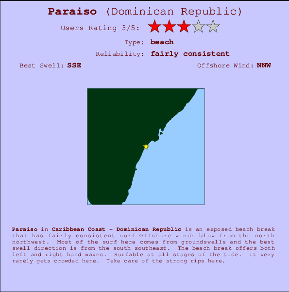
Paraiso Surf Guide
Paraiso on the South Coast is an exposed river break that has pretty consitent surf The best wind direction is from the northwest. Tends to receive a mix of groundswells and windswells and the ideal swell angle is from the southeast. The river break provides left and right handers. Unlikely to be too crowded, even when the surf is up.
Paraiso Spot Info
| Type: | Rating: | Reliability: | Todays Sea Temp*: |
|---|---|---|---|
| fairly consistent | 28.5°C*ocean temperature recorded from satellite |
Surfing Paraiso:
The best conditions reported for surf at Paraiso occur when a South-southeast swell combines with an offshore wind direction from the North-northwest.

Voorspelde Golfenergie (Kracht): 12 uur


Paraiso Surf:
Wednesday, 15 July 2026, 03:50 Local time| Tue | Wednesday 15 | |||
| 11PM | 2AM | 5AM | 8AM | |
| Wave (m) | ||||
| Periode (s) | 7 | 7 | 7 | 7 |
| Wind (km/h) | ||||
| Wind | cross | cross | cross | cross |
- /breaks/Paraiso/forecasts/latest
Paraiso Surf Guide
Paraiso on the South Coast is an exposed river break that has pretty consitent surf The best wind direction is from the northwest. Tends to receive a mix of groundswells and windswells and the ideal swell angle is from the southeast. The river break provides left and right handers. Unlikely to be too crowded, even when the surf is up.
Paraiso Spot Info
Type: Rating: Reliability: Todays Sea Temp*:  Beach
Beach 3
3fairly consistent 28.5°C*ocean temperature recorded from satelliteSurfing Paraiso:
The best conditions reported for surf at Paraiso occur when a South-southeast swell combines with an offshore wind direction from the North-northwest.
Voorspelde Golfenergie (Kracht): 12 uur
Gebruik de tabbladen hierboven om de zeewatertemperatuur bij Paraiso te bekijken, foto's van Paraiso, Paraiso gedetailleerde golfvoorspellingen, wind- en weersvoorspellingen, Paraiso webcams, actuele wind in Caribbean Coast live weerstations en Paraiso getijdenvoorspellingen. De link van Dominican Republic golfkaarten opent een grote afbeelding van Dominican Republic en de omliggende zeeën. Deze golfkaarten kunnen worden dynamisch gemaakt worden met de verschillende golfcomponenten, golfenergie, golfperiode, golfhoogte, samen met de wind en weersvoorspellingen, het actuele weer en de zeetoestand volgens golfboeien uit Dominican Republic, langskomende schepen en weerstations op de kust. Elk voorspelling pagina's voor dit surfstrand zijn voorzien van een wereldwijde en regionale golfzoeker om de beste surfsomstandigheden in het gebied rond Paraiso te vinden.
Paraiso Surf:
Wednesday, 15 July 2026, 03:50 Local timeTue Wednesday 15 11PM 2AM 5AM 8AM Wave (m) Periode (s) 7 7 7 7 Wind (km/h) Wind cross cross cross cross - /breaks/Paraiso/forecasts/latest
- /breaks/Paraiso/forecasts/latest/six_day
Paraiso Surf Guide
Paraiso on the South Coast is an exposed river break that has pretty consitent surf The best wind direction is from the northwest. Tends to receive a mix of groundswells and windswells and the ideal swell angle is from the southeast. The river break provides left and right handers. Unlikely to be too crowded, even when the surf is up.
Paraiso Spot Info
Type: Rating: Reliability: Todays Sea Temp*: Beach3fairly consistent 28.5°C*ocean temperature recorded from satelliteSurfing Paraiso:
The best conditions reported for surf at Paraiso occur when a South-southeast swell combines with an offshore wind direction from the North-northwest.
Voorspelde Golfenergie (Kracht): 12 uur
Gebruik de tabbladen hierboven om de zeewatertemperatuur bij Paraiso te bekijken, foto's van Paraiso, Paraiso gedetailleerde golfvoorspellingen, wind- en weersvoorspellingen, Paraiso webcams, actuele wind in Caribbean Coast live weerstations en Paraiso getijdenvoorspellingen. De link van Dominican Republic golfkaarten opent een grote afbeelding van Dominican Republic en de omliggende zeeën. Deze golfkaarten kunnen worden dynamisch gemaakt worden met de verschillende golfcomponenten, golfenergie, golfperiode, golfhoogte, samen met de wind en weersvoorspellingen, het actuele weer en de zeetoestand volgens golfboeien uit Dominican Republic, langskomende schepen en weerstations op de kust. Elk voorspelling pagina's voor dit surfstrand zijn voorzien van een wereldwijde en regionale golfzoeker om de beste surfsomstandigheden in het gebied rond Paraiso te vinden.
Paraiso Surf:
Wednesday, 15 July 2026, 03:50 Local timeTue Wednesday 15 11PM 2AM 5AM 8AM Wave (m) Periode (s) 7 7 7 7 Wind (km/h) Wind cross cross cross cross - /breaks/Paraiso/forecasts/latest
Paraiso Surf Guide
Paraiso on the South Coast is an exposed river break that has pretty consitent surf The best wind direction is from the northwest. Tends to receive a mix of groundswells and windswells and the ideal swell angle is from the southeast. The river break provides left and right handers. Unlikely to be too crowded, even when the surf is up.
Paraiso Spot Info
Type: Rating: Reliability: Todays Sea Temp*: Beach3fairly consistent 28.5°C*ocean temperature recorded from satelliteSurfing Paraiso:
The best conditions reported for surf at Paraiso occur when a South-southeast swell combines with an offshore wind direction from the North-northwest.
Voorspelde Golfenergie (Kracht): 12 uur
Gebruik de tabbladen hierboven om de zeewatertemperatuur bij Paraiso te bekijken, foto's van Paraiso, Paraiso gedetailleerde golfvoorspellingen, wind- en weersvoorspellingen, Paraiso webcams, actuele wind in Caribbean Coast live weerstations en Paraiso getijdenvoorspellingen. De link van Dominican Republic golfkaarten opent een grote afbeelding van Dominican Republic en de omliggende zeeën. Deze golfkaarten kunnen worden dynamisch gemaakt worden met de verschillende golfcomponenten, golfenergie, golfperiode, golfhoogte, samen met de wind en weersvoorspellingen, het actuele weer en de zeetoestand volgens golfboeien uit Dominican Republic, langskomende schepen en weerstations op de kust. Elk voorspelling pagina's voor dit surfstrand zijn voorzien van een wereldwijde en regionale golfzoeker om de beste surfsomstandigheden in het gebied rond Paraiso te vinden.
Paraiso Surf:
Wednesday, 15 July 2026, 03:50 Local timeTue Wednesday 15 11PM 2AM 5AM 8AM Wave (m) Periode (s) 7 7 7 7 Wind (km/h) Wind cross cross cross cross Tide Times:
Op Paraiso (0 km).
VOLGENDE IS OM (lokale tijd) resterende tijd hoog water laag water Paraiso Tide Times and Tide Chart
Live Weather:
At Ensanche Savica de Mendoza wx, 175 km from Paraiso.
-
dryAir temperature
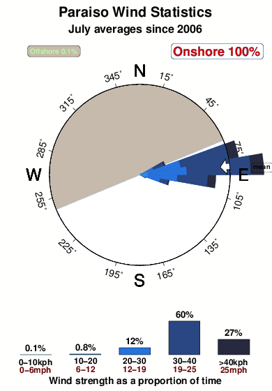
-°COverall Paraiso Surf Consistency and Wind Distribution in July
surffoto's uit
de galerijContourlijnen: Wegen & Rivieren: Kies een surflokatie uit het menu 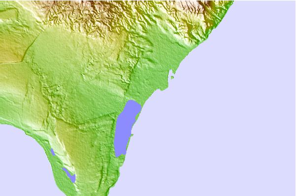
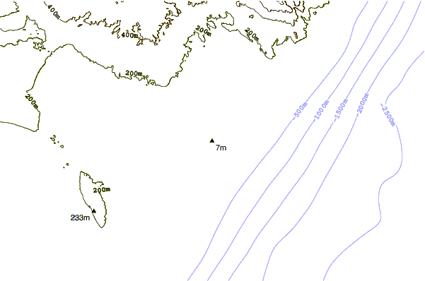
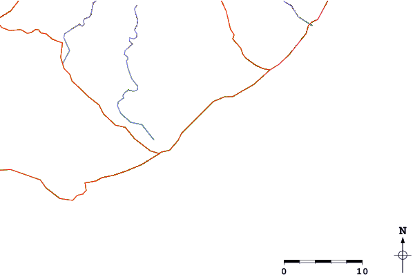
Gebruik deze reliëfkaart om naar de surfspots en de getijdenstations van Caribbean Coast toe te gaan, in de buurt van Paraiso.
Andere Dichtbijzijnde Surflocaties van Paraiso:
(klik op locatienaam voor meer informatie)- Closest Locatie1 mi
- Second closest Locatie7 mi
- Third closest Locatie11 mi
- Fourth closest Locatie15 mi
- Fifth closest Locatie17 mi
Dichtstbijzijnde golfboeien bij Paraiso:
- Closest golfboei268 mi
- Second closest golfboei316 mi
- Third closest golfboei346 mi
- Fourth closest golfboei387 mi
- Fifth closest golfboei420 mi
Getijdenstations in de buurt van Paraiso:
- Closest getijdenstationEnriquillo9 mi
- Second closest getijdenstationParaiso17 mi
- Third closest getijdenstationBarahona32 mi
- Fourth closest getijdenstationPedernales32 mi
- Fifth closest getijdenstationPaya74 mi
Airports
- The closest passenger airport to Paraiso is Maria Montez International (Barahona) Airport (BRX) in Dominican Republic, 54 km (34 miles) away (directly).
- The second nearest airport to Paraiso is Port Au Prince International (Port-au-prince) Airport (PAP) in Haiti, 134 km (83 miles) away.
- Third is Herrera International (Santo Domingo) Airport (HEX) in Dominican Republic, 161 km (100 miles) away.
- Las Americas International (Santo Domingo) Airport (SDQ) in Dominican Republic is 188 km (117 miles) away.
- Cibao International (Santiago) Airport (STI), also in Dominican Republic is the fifth nearest airport to Paraiso and is 193 km (120 miles) away.
- /breaks/Paraiso/forecasts/latest


 Nearest